FORT COLLINS, Colorado, USA – Remote GeoSystems, Inc., a global provider of geospatial video recorder hardware and GIS integration software and solutions has become an official Silver Partner in the Esri Partner Network after successfully building their business as an Emerging Business Partner in the Esri Startup Program.
Esri, the world leader in location intelligence and mapping technologies, offers a unique Startup Program enabling the most promising emerging businesses to incorporate these innovations into their services and solutions. Now in its third year, the Esri Startup Program provides the ArcGIS software, online services, support, community involvement and training to kick-start product development or enrich existing solutions.
Remote GeoSystems was one of the first accepted early stage startups in to the program. “As a small technology company bootstrapping the development and innovative product sales efforts, access to Esri’s flagship ArcGIS platform and team support was invaluable,” said Jeff Dahlke, Managing Director of Remote GeoSystems.
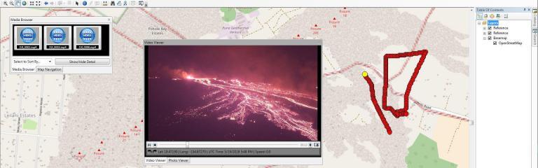
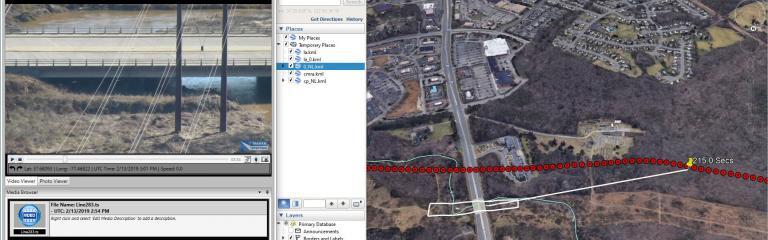
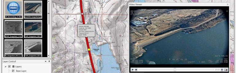
In their three years in the program, Remote GeoSystems was able to successfully develop and go-to-market with an array of geospatial video solutions. Their LineVision Esri ArcMap Add-in and stand-alone LineVision Desktop with Esri Mapping commercial software tools provide georeferenced video playback, analysis, collaboration and reporting using the Esri ArcGIS platform. In addition, the new Video GeoTagger™ and Video GeoEditor™ (coming soon) products, also built with Esri mapping technology, will be available for use on the ArcGIS Marketplace. These professional geospatial video and integrated GIS Full Motion Video (FMV) software tools are ideal for airborne, drone and mobile mapping surveys, critical infrastructure inspection and public safety applications.
“The Remote Geo team is building some very feature-rich and capable Esri-based solutions and Add-ins while also bringing a valuable mix of GIS, GPS, deep location-based video expertise and multi-industry experience,” said Francis Kelly, Esri Global Partner Programs Manager. “We are excited to work with Remote Geo as their business matures and they continue to contribute to the Esri user community as part of the Esri Partner Network.”
“As a company that was once a startup, we understand the early years for any business are hard,” said Katie Decker, Esri Startup Team Community Manager. “We are impressed with how the Remote Geo team executed on the opportunities provided by the program, bringing value of geospatial video to a broader audience using the Esri platform. Their experience is what we envisioned when we implemented the program and we look forward to continuing to work with them.”
Remote GeoSystems LineVision Esri-based solutions key features often include:
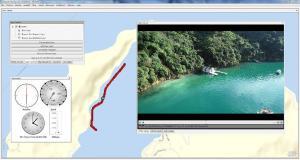
– Play videos from single and multi-camera video data collection platforms
– “Click-on-Map” video navigation
– Set a custom geo-fence around the moving position marker
– Load shapefiles, imagery and ArcGIS Online datasets
– Save geotagged video and photo data as geoProjects™ for simple project reporting, archive and search
– Industry-leading support for DJI Drone Video data
All Remote GeoSystems Esri-based solutions are available in the ArcGIS Marketplace.
###
About Esri
Esri, the global market leader in geographic information system (GIS) software, offers the most powerful mapping and spatial analytics technology available. Since 1969, Esri has helped customers unlock the full potential of data to improve operational and business results. Today, Esri software is deployed in more than 350,000 organizations including the world’s largest cities, most national governments, 75 percent of Fortune 500 companies, and more than 7,000 colleges and universities. Esri engineers the most advanced solutions for digital transformation, the Internet of Things (IoT), and location analytics to inform the most authoritative maps in the world.
Learn more at www.esri.com
###
More Articles & News
Check out related articles, news and product updates from Remote GeoSystems.