

Home > Mapping Software > LineVision Desktop
LineVision Desktop
Desktop Geospatial Full Motion Video & GIS Data Mapping Software
Starting at $29/month
The world's most comprehensive and flexible software for mapping, analysis, packaging and reporting using georeferenced videos, photos, documents/files and other sensor data from survey, inspection and surveillance data collection platforms.
LineVision Desktop is the most powerful and adaptable software offering in our LineVision suite of integrated desktop-based applications, add-ins and extensions for working with geospatial video survey, inspection & surveillance project data.
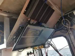
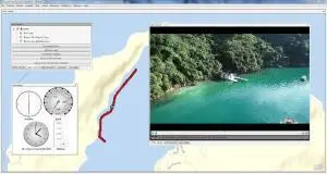
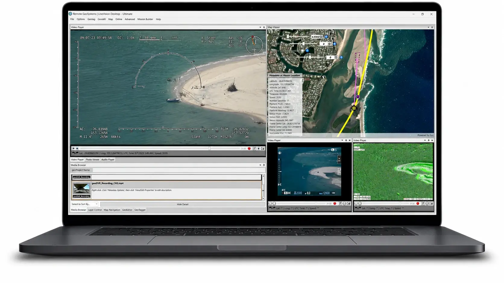
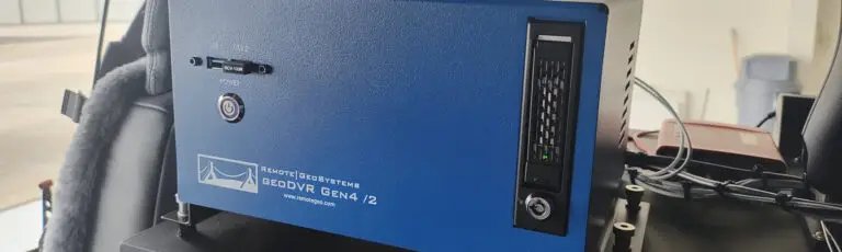
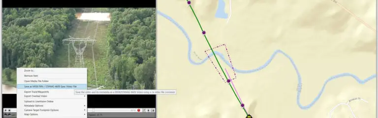
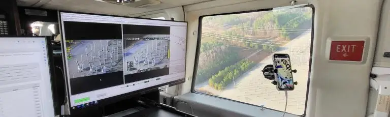
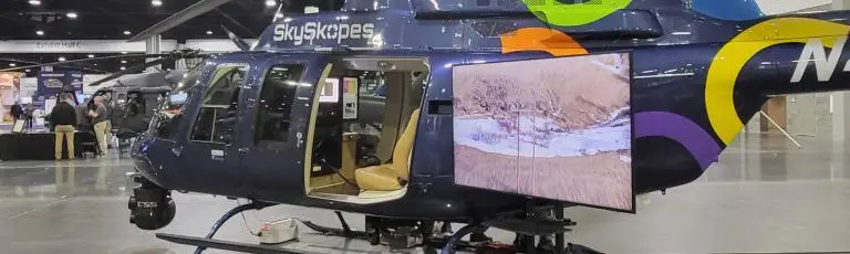
With LineVision Desktop, users of any skill level can easily geotag, create and playback geo-referenced video files and MISB Full Motion Video (FMV) / STANAG 4609-spec videos from nearly any video camera or recorder, including; consumer action cameras, professional drones & unmanned vehicles, gyro-stabilized gimbals, subsea rovers and our own purpose-built geoDVR multi-sensor video recording systems.
Along with video, LineVision Desktop also supports mapping, data-fusion, visualization and creation of interactive “geoProject” deliverables using still-image photos, documents/files, specialized sensor data and traditional geospatial data types.
As a “stand-alone” geospatial software, LineVision Desktop utilizes Esri’s world-class ArcGIS mapping technology, but does NOT require the users to already have an ArcMap or ArcGIS Pro.
Now even those without direct GIS experience can easily view and manipulate valuable and immersive location-based asset multimedia files along with enterprise maps and imagery data provided by Esri and other compatible GIS tools.
Share this page with Colleagues & Clients!
Features & Capabilities
LineVision Desktop offers the industry’s most complete and unique set of geospatial media and data mapping and reporting capabilities for survey, inspection and surveillance projects
(Click to expand. Features vary by edition)
- Playback and View GPS-linked Videos, Photos & Audio on Maps
- Navigate Video by Clicking on Map GPS Tracks & POI Waypoints
- Support for Numerous Video & GPS Data File Formats
- Simultaneously Playback up to 4 Videos from the Same Platform
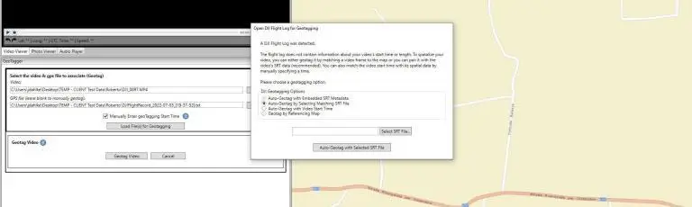
- “Automatically” Geotag Videos with Continuous GPS Log Files
- Click on Maps to “Manually” Geotag Videos without GPS
- Geotag High-Resolution Oblique Photos in Batch and Individually
- Optimize Photos and Video Frames for Photogrammetry Tools
- GPS-enabled Action Cameras like GoPro, Garmin, Sony and More.
- Multi-Sensor Airborne Gyro-stabilized Gimbal Camera Systems
- geoDVR Geospatial Video Recorders & Compatible DVRs
- Drones, Subsea ROVs and other Remote Sensing Video Systems
- MISB FMV Spec Videos with KLV Encoded Metadata
- Remote GeoSystems Spec Camera-Target-Footprint (CTF) Videos
- Easily Prepare DJI Drone Metadata for Esri’s FMV Multiplexer Tool
- Cut & Splice Geotagged Videos by Clicking on the GPS Track
- Export Videos with Text, Lat/Long and Logo Overlays
- Multiplex Up to 4 Video Cameras Feeds into 1 Output File
- Join Together Different Video Segments with GPS
- Auto-generate Microsoft Word and Excel Reports
- Export Text and Lat/Long Overlay into Video Closed Captioning
- Create, Save and Share geoProjects for other LineVision Versions
- Export Future Mission Plans as KML
- Interactive Map Interface Leveraging Esri GIS
- Esri-based Streets, Imagery, Topo & Oceans Base Maps
- Add Shapefiles & Raster Imagery and supported KML
- Stream Maps from ArcGIS Enterprise & ArcGIS Online
- Add Metadata & Descriptions to Videos, Photos, POIs & More
- Attach Notes & Files to Map Locations
- Available Support for Remote Sensing Data Systems
- Industry-leading DJI Drone Data Mapping & GIS Integration
- Military UAVs Using the MISB FMV/STANAG KLV Spec
- Gimbals Using the Remote Geo Camera-Target-Footprint Spec
- Specialized Subsea ROV Underwater GPS Systems
Multiple Editions
Specifications & Requirements
GPS Video & GPS File Support
- Video File Format: .MP4, H.264, .AVI, .TS, .MOV, .ASF, .PS, .VOB, .MPG4, .MPEG4, .MP2, .MPG2
- GPS Companion File Format: .GPX, .CSV, KML, .TXT, .LOG, .FIT (Garmin VIRB, other), .SRT/Flight Record Log .TXT (DJI drones), .SKY/.UTM (Yuneec drones), .MOFF (Sony action cameras), .RGPS, .XML (Cloud Cap Technology, Red Hen Systems)
- Embedded Video GPS Metadata: MISB Full Motion Video (FMV), GoPro embedded GPS, DJI closed captioning, Remote GeoSystems “Whisper” (our Patented, “Constantly-Persistent” GPS Encoding)
Geo-tagged Photo Support
- Geotagged .JPG files with GPS metadata in the EXIF header
- Non-geotagged .JPG files (can be geotagged in LineVision Desktop)
Geospatial Map Data Support
- Vector Files: Esri-compatible Shape Files (SHP)
- Raster Imagery Files: Esri-compatible Raster Imagery files.
- Streaming Data Endpoints: Esri-compatible Streaming Data Endpoints (ArcGIS Server, ArcGIS Online, etc.)
geoProject Packaging
- Remote local GeoSystems .geoProject file
- Remote GeoSystems portable “Uncompressed” .geoProject file
- Remote GeoSystems portable “Compressed” .geoProject .RGS file (similar to a zip file)
Recommended Windows PC Specifications
(NOTE: For video creation, transcoding, geo-editing and MISB FMV/STANAG 4609 embedding, the recommended or better is needed.)
Processor: 10th Generation Intel Core i7 or better
Ports: USB 3.1
RAM: 32 GB Minimum
Hard Drive: 1 TB Minimum (or more depending on recording length. Ample storage is recommended as video files can take considerable space).
Video Card: Minimum of 4 GB of memory
Minimum Windows PC Specifications
Processor: 9th Generation Intel Core i7 or better
Ports: USB 3.1
RAM: 16 GB Minimum
Hard Drive: 1 TB Minimum (or more depending on recording length. Ample storage is recommended as video files can take considerable space).
Video Card: Minimum of 4 GB of memory
Pricing & License Plans
LineVision Desktop is offered in Monthly, Annual and Perpetual license plans. Purchase a license now at our online store or from within the application after downloading the trial. Enterprise licensing is also available.
(Clicking Buy Now will take you to our shopping cart for secure checkout)
Basic
Geotagging, Interactive Viewing & Analysis- $29 - Monthly
- $299 - Yearly
- $725 - Perpetual
- Enterprise Licensing - Contact
Professional
Build, Save & Update geoProject Deliverables- $59 - Monthly
- $599 - Yearly
- $1,550 - Perpetual
- Enterprise Licensing - Contact
Ultimate
Editing, Reporting, Mission Planning & More!- $119 - Monthly
- $1,199 - Yearly
- $3,000 - Perpetual
- Enterprise Licensing - Contact
LineVision Desktop News & Updates
Check out the latest LineVision Desktop related news and updates from Remote GeoSystems.
Ready to Get Started?
Free Trial
Buy Now
Schedule Demo
Support Resources
LineVision Desktop User Manuals, How-to Videos and User Forums to help get you up and running fast!
Related Software
Check out related professional LineVision software options that support the Remote GeoSystems “geoProject” deliverable format – as well as our consumer Video GeoTagger / Video GeoEditor applications.